

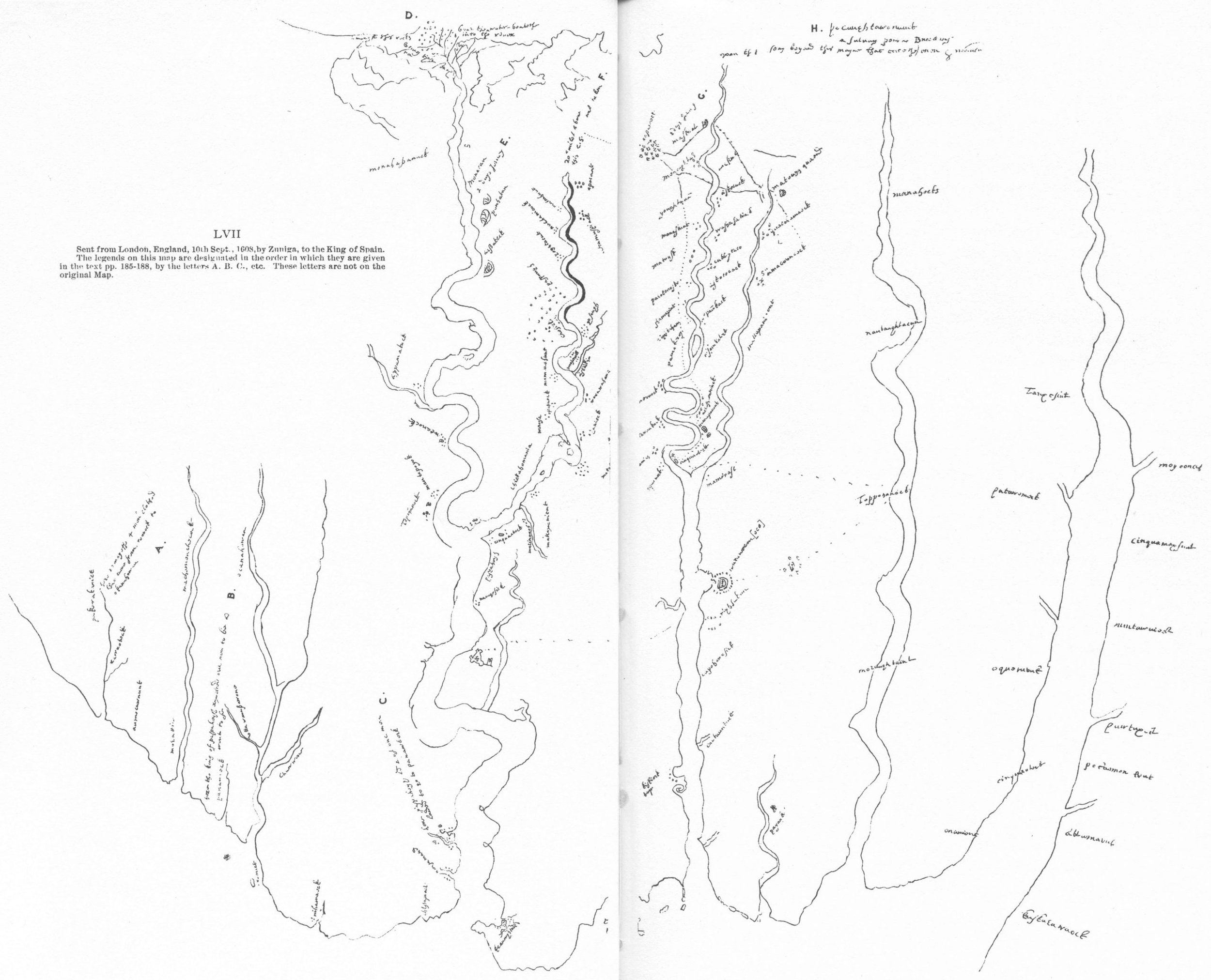
The Zuniga Map, 1608
A Manuscript

A detail from the Zuniga map showing Jamestown fort with the James River to the left and below. The narrower channel to the right is Back River.
Rediscovered in Spanish archives at Simancas in the 19th century, Smith’s authorship is uncertain though widely supposed. It is of primary importance in reconstructing Smith’s capture route. The name derives from that of the Spanish ambassador to London, Pedro de Zuniga, who sent it in a diplomatic dispatch to the Spanish court.
If the Velasco map shows some skill and attention to detail, beside it the Zuniga map, our principal source for the capture route, is hasty and crude. Even so, in parts it repays close attention, such as the careful outlining of the curl of Penniman Spit on the York River, the topography of the lower Pamunkey River, and the precise shape of James Fort. The North Carolina portion, apparently ignorant of outer banks, borrows nothing from John White’s excellent map of Roanoke, c. 1587 or de Bry’s 1590 published and widely circulated engraving of it, either in labeling or topography. Instead it appears to be based on information returned from an expedition by two unidentified Englishmen sent south from Jamestown to Panawick “beyond Roanoke” in February 1608, and possibly the expedition of Powell and Todkill the following December beside the label Mangoags.
The Zuniga mapmaker was well aware of Jamestown’s Back River (pictured) but ignorant of other bodies of water such as the Pagan, Nansemond, and Elizabeth Rivers.
This makes up the left side of the map. In the center, James and York River portions are fully developed (the Rappahannock much less so) with reasonably accurate topography and place names, as well as the crucial detail of the capture route. North of that, which is the right side of the map, topographic ignorance returns with a sprinkling of Smith’s summer-of-1608 place names from the Potomac River and Chesapeake Bay written along a single large estuary that combines to represent both.
The Zuniga map shows permanent Powhatan settlements and labels two hunting camps. The symbol is graphic, being a cluster of dots either strung along the riverside for a mile or more or concentrated, often with a principal house among them. Several place names appear on the map that have no settlement symbol. Unfortunately, two of these are Youghtanund and Toppahanock, important capture-route stopovers.
Who Drew the Zuniga Map?
The drafter of the Zuniga map is regularly assumed to be Smith. In fact, opinion in general is that the Zuniga map, so called, was drawn by Smith to illustrate the events described in his letter published as A True Relation. There are two problems with this. First, the majority of place names differ from the spelling in Smith’s works, as varied as his are in themselves. Second, it assigns the date of the map to no later than June 1, 1608, when Smith’s letter left aboard the Phoenix for England but Smith himself remained in Virginia. However, the map contains bits of geographic information from a later date and lacks one significant feature from a prior date, namely Smith’s visit to the Nansemond River in April, shown as hardly more than a cove in the riverbank. Perhaps we should do a handwriting comparison with Smith’s letter to the cordwainers.
Foremost of later date features is the careful and highly accurate rendering of the lower courses of Skimino Creek, directly across from and just south of Werococomoco on the York River. The first Englishmen we know of at all likely to have gone that way would be Smith and four others on the way to a rendezvous with Newport, who was coming by water to stage the so-called coronation of Powhatan. That was in the autumn of 1608.
Other details would be the names of Indian king’s houses Smith did not visit prior to the summer of the same year. It is true that in A True Relation he claims to have been taken to the Potomac River on his capture march, but some of the Zuniga names—Pawtuxunt, Kuskarawaock, Moyoonch—too far up the Bay and the Potomac to have conceivably been reached by Opechancanough or Kekataugh escorting their captive. He does not repeat the claim in The Generall Historie. Thus we may have a map drawn by someone late in 1608, collecting information at Jamestown, one of his sources being Smith.
Other Candidates

Who drew the Zuniga map? Four possibilities besides were Waldo the gentleman, Collier the boy, Brinton the mason or the mysterious Buckler.
(Photos: Connie Lapallo)
If we eliminate Smith, we might consider one of the four who went with him to Skimino Creek, who are Captain Richard Waldo, Edward Brinton, Samuel Collier, and Master Andrew Buckler.
Waldo was a gentleman and member of the council, having arrived that fall in the second supply. But he accompanied Newport’s Monacan expedition, so his knowledge of the upper James excludes him. He drowned in early January 1609 in the James River off Hog Island along with ten others when their boat capsized. Smith wrote that he knew him to be “sure in time of need.”
Brinton was a mason who arrived as a member of the first voyage and is listed as a soldier in January 1609.
Collier, listed as a boy on the first voyage roster, was to be left at Werowocomoco to be Powhatan’s “page, to learn the language.”
That leaves Master Andrew Buckler. The name appears in the record here and nowhere else. He is not in any supply roster. He is not on the roster of the January 1609 expedition to Pamunkey. Perhaps he came and went with Newport’s second supply, which left in November. Hence his name never clears at Jamestown. Master was a title of address indicating accomplishment, either of social or professional rank. However, in immediate proximity with Waldo’s name, it very likely denoted the former.
Was the Zuniga map drawn by Buckler? Isn’t this just the sort of busy project a curious newcomer would jump on? Or was he a spy for the Spanish? or for the earl of Salisbury? Buckler could be our man and still not be a spy but a tool of spies. Nevertheless, the appearance of the map suggests something roughed out in Virginia and hastily done up in London.
It is only fair to mention another possibility, an anonymous one, someone who, before returning to England, initially acted as an overseer or spokesman (translator?) for the German carpenters who arrived with the first supply and in time sought to betray the colonists to the Indians. But that is pure conjecture.
The Zuniga Map, named for Don Pedro de Zúñiga. (Credit: Houghton Mifflin Company, via Encyclopedia Virginia)
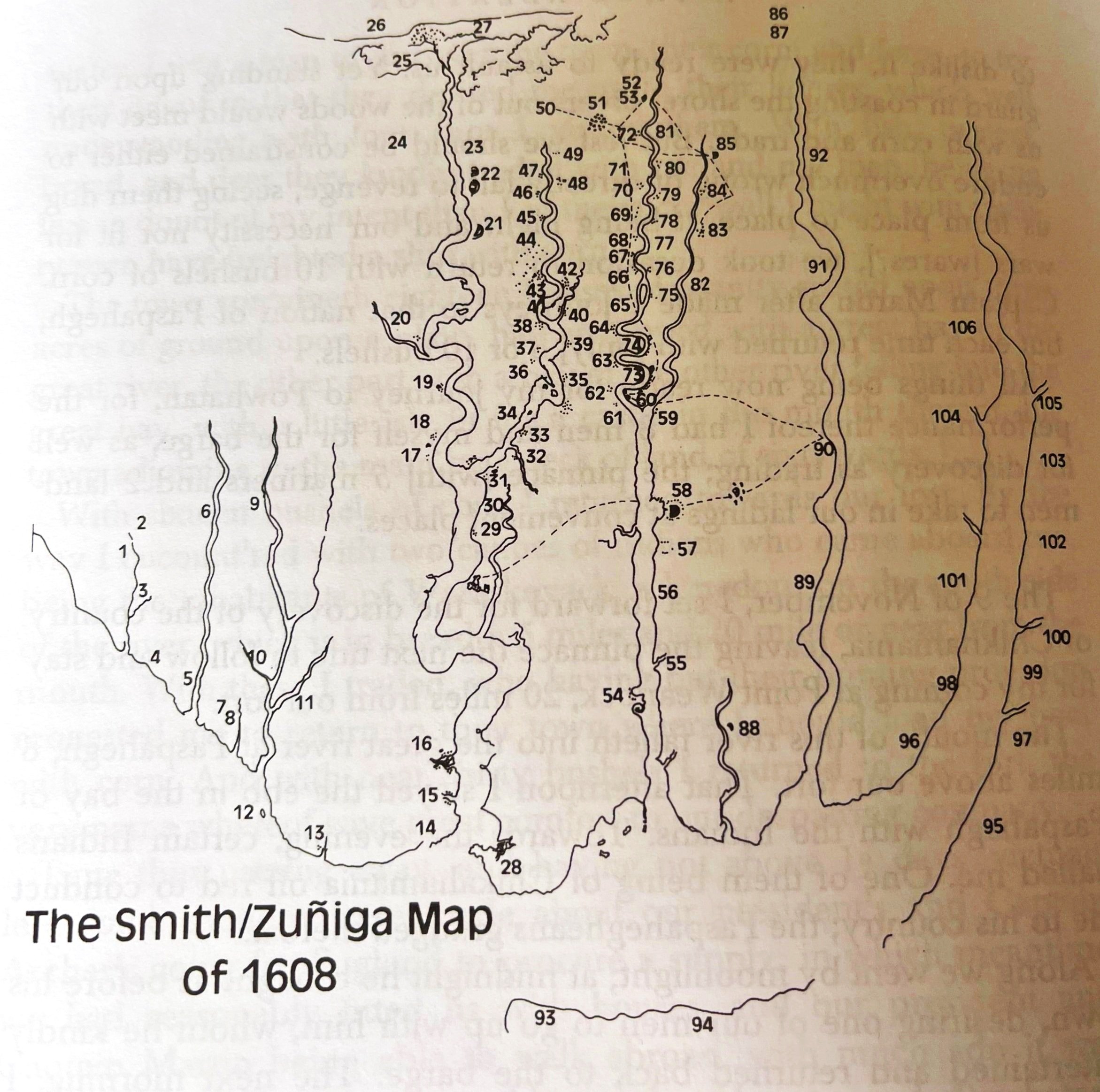
The Smith/Zuniga Map redrawn and transcribed from a copy in the Library of Congress. Numbers indicate Indian towns.
Credit: Jamestown Narratives (1607-1617), by Edward Wright Haile, p. 152. Used with permission.
Zuniga Map Place Names
1 pakerakanick
2 here remayne the four men clothed that came from roonock to okanahowan
3 rawcoteck
4 aumocawnunt
5 morattico
6 machemenchecock
7 here the king of paspahegh reported our men to be and went to se
8 panawieck
9 ocanahowan
10 uttawmussawone
11 chawwone
12 raonock
13 nihamaock
14 chissapiack
15 nansamund
16 here paspahegh and 2 of our men landed to go to panawieck
17 Tapohanock
18 mantapoyek
19 weanock
20 appamatuck
21 arssateck
22 powhatan
23 monacan 2 days Iorney [journey]
24 monahassanuck
25 being the south sea
26 amongst theis rocks
27 hear the salt water beateth into the rever
28 kequoughtan
29 namqosick
30 paspahegh
31 cinquaoteck
32 marinough
33 mattapanient
34 Chickahomania
35 ozanieck
36 mansa
37 opahaock
38 mamanahunt
39 werawahone
40 askakip
41 mosonek
42 qosaugh
43 chosicks
44 paspanigh
45 roghtacut or yoghtacut
46 nechanicock
47 mattahunt
48 attamuspinck
49 apocant
50 20 miles aboue this C[aptain] S[mith] xxxx was taken
51 rassaweck
52 2 days Iorney [Journey]
53 maskunt
54 kiskieck
55 cantaunkack
56 capohowoseck
57 wighsakan
58 warawocomo
59 mamanasi
60 cinquaoteck
61 oquonock
62 mattchamins
63 potawunkack
64 weanock
65 pamakeroy
66 righkahauck
67 shamapint
68 parokonosko
69 matunsk
70 manaskunt
71 youghtanan
72 menoughtass
73 manapacunt
74 accossomwinck
75 osamkateck
76 opawnkack
77 askecocack
78 cakkiptaco
79 washasatiack
80 askecack
81 enekent
82 mattapanient
83 amacauncock
84 quacohamaock
85 matoughquaend
86 pocoughtawonauck
87 a saluag [savage] people Dwelling vpon this seay beyond this mayne that eateth men & women
88 payankatank
89 moraughtacut
90 Toppohanock
91 nantaughtacun
92 manahocks
93 accawmack
94 accuohack
95 kuskarawaock
96 onamient
97 attamaunk
98 cinquaoteck
99 pokaomonekent
100 pawtuxunt
101 oquotaunk
102 nuntawineck
103 cinquamaxsunt
104 patawomeck
105 moyoonch
106 Tanxesint
The dotted line shows the route Smith was taken as a captive.

Has anyone done a handwriting comparison with Smith’s letter to the cordwainers?